Stumbled on some Lego models of Portland Sky Scrapers.
Category: nerd
Support Karma
I had a little bit of tech support karma pay itself back today when I was helping a befuddled student. I was out of ideas so I simply googled the error message and the answer came up on a page that I created over a year ago. Thank you digital brain.
Friday shitlist: PHPShell
I can’t decide which should be on my shit list: PHPShell or the staff member who installed it in his account with public access.
I suppose you should blame the users, not the technology, right? Kind of a cool utility if you have no regard for security. Unfortunately, someone was using it to launch a DOS attack on a gaming server.
Final map
I’ve just finished (well, not finished..) my WebGIS course map. I’ve done the 5 objectives and then some, but there are still a few things I’d like to work on – like querying. Still, I should finish up for a bit and work on my other final since it’s coming up first.
If you notice anything that doesn’t work, or would make it better, let me know. The labeling is a bit crappy, but I’m not sure how to fix that yet. Soon…
Maps to drool over
Yesterday I attended a talk on U of O’s upcoming Atlas of Yellowstone. It’s still in the early development and fund-gathering stages, but if it’s as lovely as their Atlas of Oregon, I’ll want to get a copy. The atlas is made from the compiled work of students, faculty, park representatives and data from a variety of sources. Some of the data is a proxy when the “perfect” data source isn’t available, and some is directly from the individual subject area experts form the Park Service.
One of the things I’m most impressed by with the the atlases is the consistency of color and style used in all the maps, charts and data. The consistency is great – but the color ramps, gradients, etc. are all so delicious that it’s hard not to blatantly “borrow” them.
Additionally, the Infographics lab also showed their beta of the new campus map. I wonder how difficult it would be to create a comparable tool for PSU. Especially one that didn’t require the various commercial software titles. It’s hard to beat the flash interface though. Vectors > Raster.
I heart MapServer
I’ve been really enjoying my work with UMN MapServer. It’s so easy to use, and it can share data with WMS and WFS. I think I sense a thesis topic….
Installed Windows
I spent way too long trying to figure out the best way of making my installation of new windows sound like I had installed the operating system.
- “I installed windows yesterday”
- “I installed the latest windows..”
- “The new windows provided a challenging install”
Yup… dumb. But so much quieter than the 93 year old double-hung, single-panes that we replaced.
Sorry pumpkin, daddy forgot the lyrics
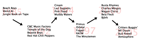
I’m finding that I’ve forgotten 95% of all the song lyrics I ever knew. I’ve discovered this because I get 4-5 words into a chorus singing to Ella when I have to pause, then start making up lyrics, usually involving Ella, poo, diapers, and daddy’s crappy memory. Michelle’s never too far away and will offer a word or two after watching me toil. She remembers lyrics.
I suspect my lyrical memory has been degraded because of my change in musical tastes. Michelle offered that maybe the beer made me forget, but I suspect its the absense of lyrics in most of my music. Here’s a simple diagram of music tastes. The saddest thing? The lyrics I remember best without cues from the song? Weird Al and Jungle Book.
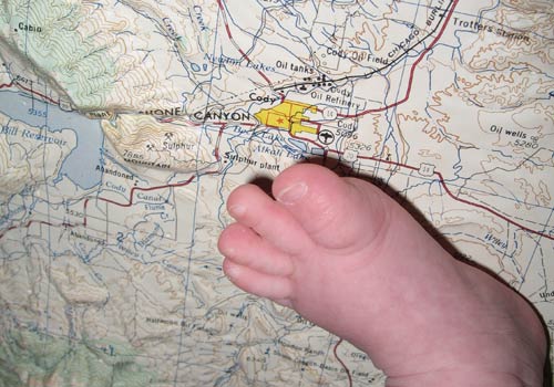
Stupid Baby Tricks
I suppose “stupid father tricks” would be more accurate, but I took this photo of Ella’s giant foot stepping on Cody, WY where I grew up. I picked up the extruded plastic topo map at the FOG map sale.
Vi with one hand
Using the vi editor with one hand is like, well, using the vi editor for the first time. Ella and I were editing map files and she fell asleep in my right arm. I had to change a few values still, so I was able to replace individual characters, but trying to remember some commands that were all done by my right hand was difficult.